The Tunnel Bluffs Trail is your ticket to spectacular panoramic views of Howe Sound, Bowen Island, Horseshoe Bay and Vancouver Island. The trail itself is moderate and can be tackled by hikers of all skill levels. This is the perfect hiking option in the fall and winter as it stays snow free for most of the year. The trail requires hikers to climb about 470m in elevation over 2km of switchbacks and the final 2-3km of the trail is flat. On the journey to the viewpoint there are some fun log bridges to cross and a few small runoff waterfalls. At a fast pace you can complete the trail in 2-3 hours but, on a clear day, you are going to want to spend a solid chunk of time soaking in the views.
Remember the Backcountry Basics
- Carry your Survival Kit & Essentials
- Let someone know where you’re going with a Trip Plan
- Know how to avoid negative wildlife encounters
- Practice Leave No Trace to keep the wilderness pristine
- Carry a Satellite Communicator like SPOT X
Table of Contents
The Breakdown
| Distance (Round Trip) | 11km |
| Elevation Gain | 478m |
| Time (Round Trip) | 3-5 hours |
| Dogs | Yes |
| Camping | No |
| Season | Year Round |
| Difficulty | Moderate |
| Remoteness | Heavily Trafficked |
| Highest Point | 688m |
Driving Directions & Parking
The Tunnel Bluffs viewpoint trail is located in the village of Lions Bay. To get to Lions Bay Drive North on BC-99 towards Squamish/Whistler. Exit toward Lions Bay Avenue from the highway. Follow Bayview Rd and Mountain Drive to Sunset Drive. You can also just follow the signs towards the ‘school’ and then continue up the road from the school until you reach the Sunset Drive Trailhead parking area.
Parking can be troublesome in Lions Bay in the summertime. At the trailhead at the top of sunset drive there are only about 15 parking spots and it is PAY parking during summer. There are tons of ‘permit parking’ only areas in Lions bay and if you can’t find a spot to park, or you want to park for free, your only option is to park down at the elementary school, or down at the south end of Mountain view Drive by Timbertop Drive. Parking at the elementary school tacks on a bit of elevation, but it’s a good warm up before you hit the trail and will save you 10 bucks!
Pro Tip: In the Fall/Winter parking is free and way less people hike the trail, so winter is the ideal time to hike this trail.
The Route
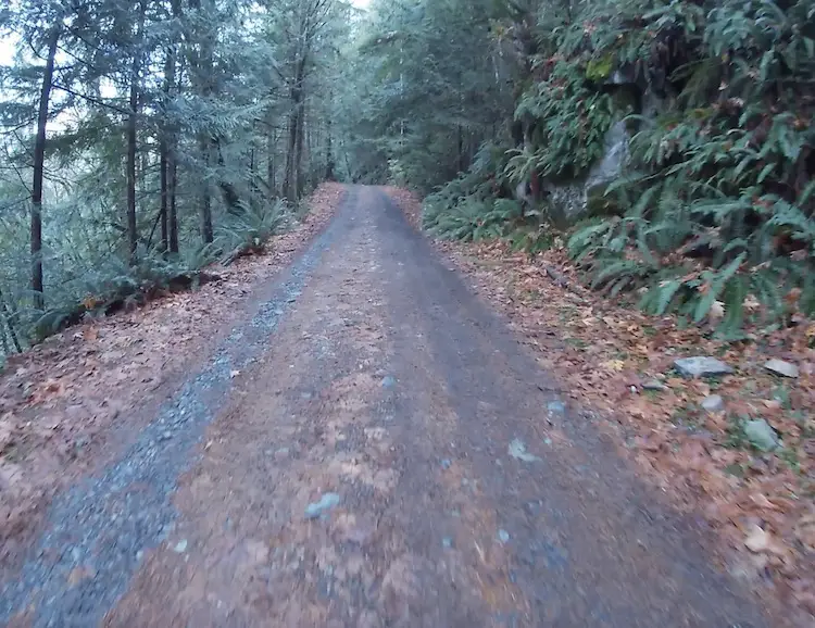
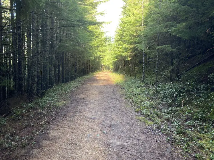
The trail begins on the gravel road just beyond the yellow gate. You will be tackling the majority of the elevation right out of the starting gate. After 300m you will pass the Harrison trail to your left and then a water station to your right, continue to follow the gravel road. About 15 minutes later at the 1km mark you will arrive at a clearing and fork in the road, stay right at the fork and once again, continue along the gravel road.
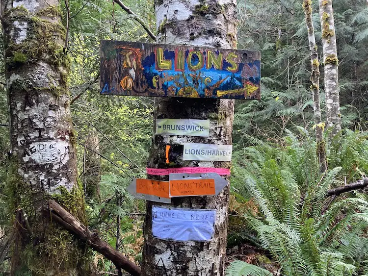
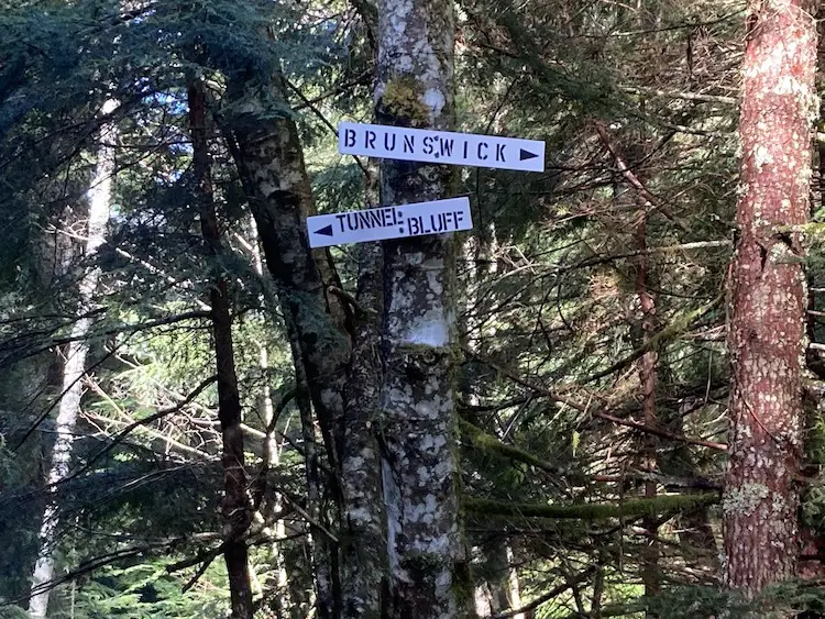
Once you hit the 2km mark the grunt work is over. You will arrive at a junction with a number of signs pinned to a tree. Follow the signs left towards the Brunswick and Tunnel Bluffs trail.
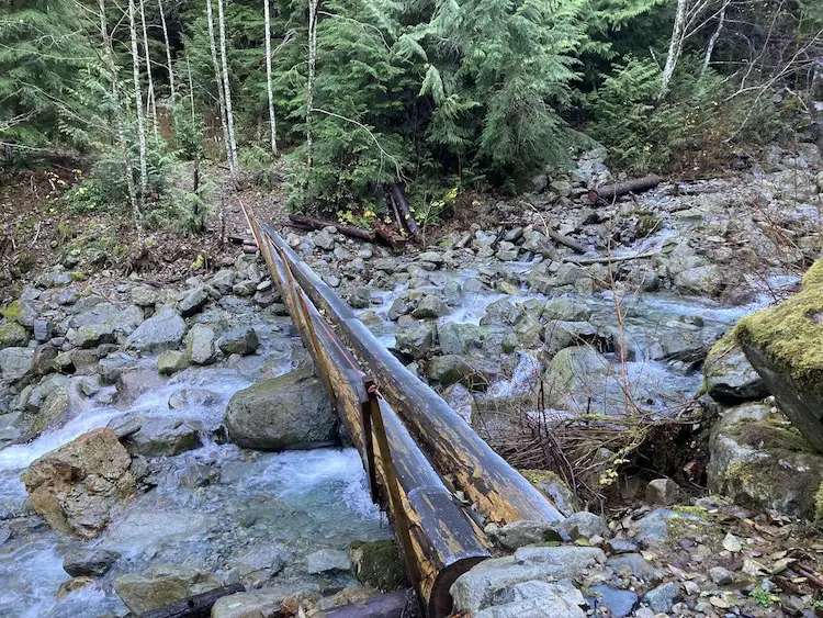
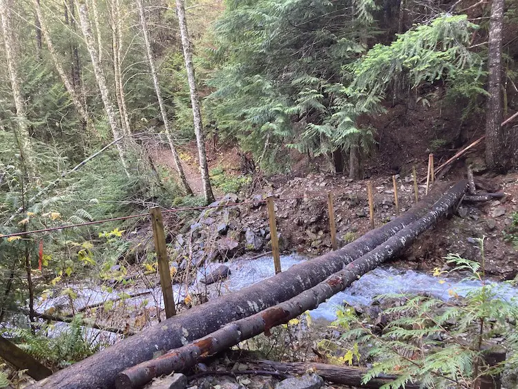
The trail flattens out and you begin to traverse through the mountain side on a muddy logging road. At the 2.6km mark you will pass over a beautiful log bridge over Magnesia Creek.
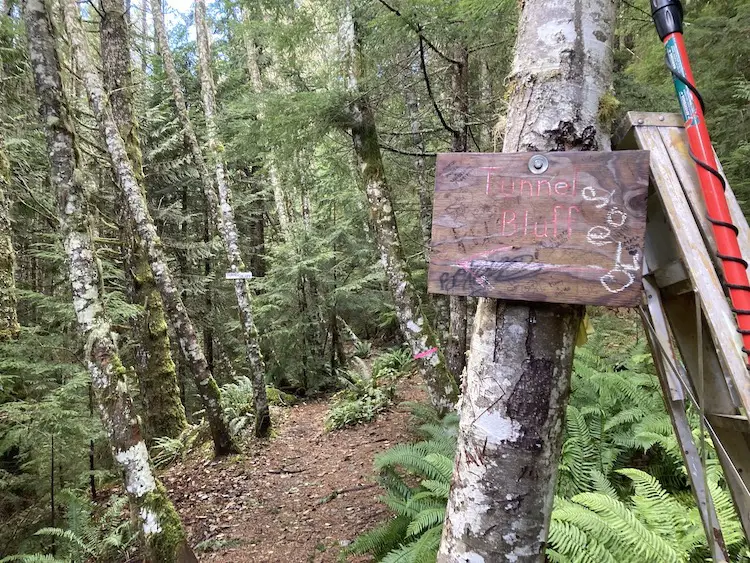
Soon after you will arrive at another junction. There are two signs nailed into the trees, right to Brunswick and Left to Tunnel Bluffs.
Take the trail to the left and head off into the trees. At approx. the 4km mark you will reach another awesome log bridge. On a clear day you can see a bit of the ocean through the trees to your left when standing on the bridge.
Continue across the bridge and along the trail until you arrive at the junction for the Tunnel Point Trail (old tunnels bluff trail) which leads down to highway 99. Continue on the trail until you reach another junction, Right to Hat Mountain and left Tunnel Bluffs, continue left to the viewpoint.
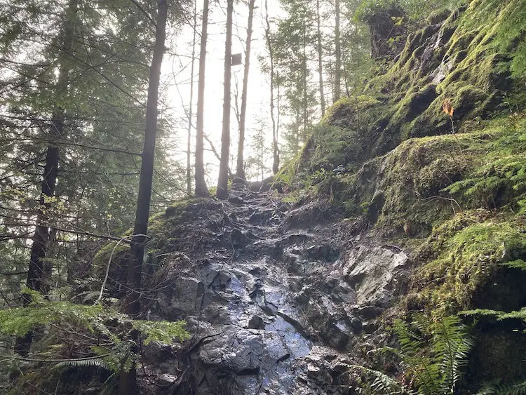
The short section of trail beyond the Hat Mountain junction is probably the most technical of the hike. It is rocky and can be slippery if wet, so make sure you take your time and have decent footing on the way up. There is a rope to help assist hikers if needed.
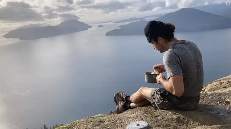
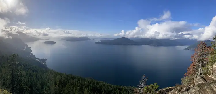
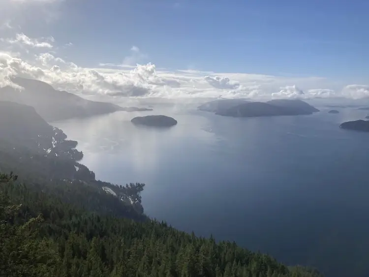
The viewpoint is down to the left after the rocky/rope section. Don’t get too excited by the view and climb carefully down the rocks until you reach a nice flat spot to take some photos and have a snack. The viewpoint is absolutely breathtaking. It exhibits one of the most exceptional panoramic views of Howe Sound in the sea to sky corridor. You can see Bowen Island, Horseshoe Bay, and Vancouver Island in the horizon.
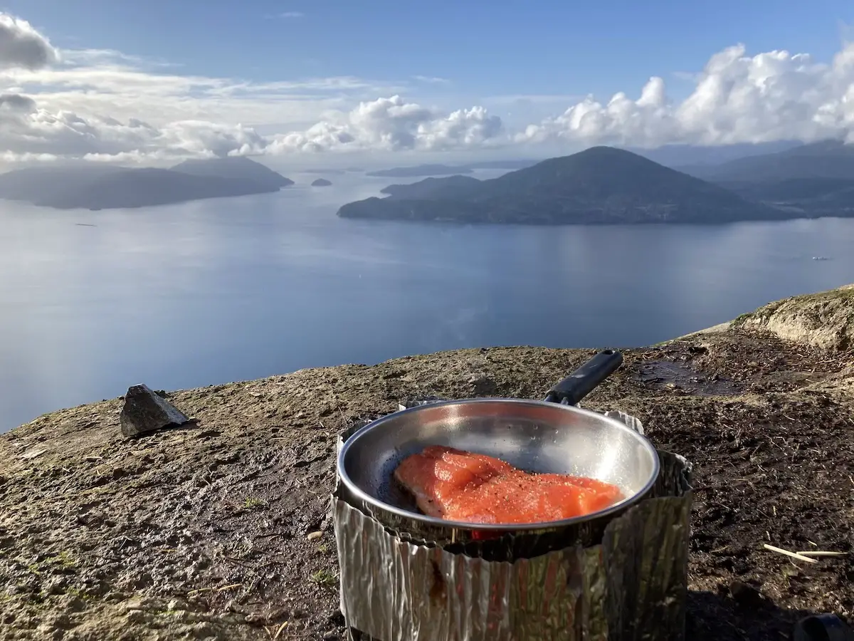
I love the Tunnels Bluff so much I actually hiked freshly caught coho and carried the necessary ingredients to the top to cook up a salmon crème penne.
The Old Tunnel Bluff Trail?
The original Tunnels Bluff trail begins on the side of highway 99 across from the tunnel point parking lot. Due to the popularity of this trail, and traffic on the highway, a 30 minute max parking rule has been put in place at the tunnel point parking area. Hikers have created the new ‘recommended’ route from the Sunset Drive parking area so trail lovers can still enjoy an easy and enjoyable hike to the viewpoint There have been many reports of people being towed in the tunnel point parking area so it’s best not to take any chances.
If you want to hike the old trail you absolutely can! Park your car in Lions Bay and then walk along the side of the highway to the old trail. It’s still well marked and I’ve hiked both quite recently. There aren’t any major advantages to hiking the old trail. It requires more elevation gain, is quieter, narrower and has a less maintained feel. Overall the bread and butter of the trail is the view and honestly it doesn’t really matter to much how you get up there.
Additional Considerations
- Although the terrain is simple I would recommend a decent pair of hiking boots to provide traction and prevent ankle rollovers
- It can be extremely busy on weekends in the summer, so, winter or weekdays are the best time to attempt this trail
- There are bears in the area so always carry a can of bear spray
Frequently Asked Questions
Are dogs allowed on Tunnel Bluffs?
Yes. Dogs are allowed on leash in the trails.
How long does it take to hike Tunnel Bluffs?
Typically it will take hikers anywhere from 3-5 hours depending how long you decide to hang out soaking in the beautiful views.
Should I wear hiking boots on the Tunnel Bluffs?
Hiking boots are recommended as there are wet sections and some rocky/rooty terrain to climb near the top.
Where is the Tunnel Bluffs Trail?
The Tunnels Bluff viewpoint trail is located in the village of Lions Bay. To get to Lions Bay Drive North on BC-99 towards Squamish/Whistler. Exit toward Lions Bay Avenue from the highway. Follow Bayview Rd and Mountain Drive to Sunset Drive. You can also just follow the signs towards the ‘school’ and then continue up the road from the school until you reach the Sunset Drive Trailhead parking area.
Can I hike Tunnel Bluffs in Fall/Winter?
Yes! Tunnels Bluff is best to hike in the fall and winter. Parking is free, the trail is quiet and since the elevation is low there will not be any snow unless there is snow in the city.
Let me know if you have any questions in the comments.
Happy Hiking!